Maps - Pickens County South Carolina SC

Maps of Pickens County, South Carolina


Pickens County Websites | Places in Pickens County | Other SC County Maps | All SC Maps

Overview 
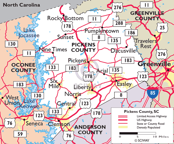
Map of Pickens County

  • Click here for more Pickens County maps.


More Pickens County Maps

Thanks for using SCIway.net's
Pickens County SC maps guide!


Common misspellings: southcarolina sout souh soth suth outh so carolin carolia carolna carolina carlina caolina crolina arolina caroli carolins carlina carolinas carilina caralina corolina drving driveing dirving streetmap satelite

Related search terms: s.c. carolina's g.i.s. geographic information system street streets road driving directions direction highway highways state cities counties atlas travel traveling where can i get find finder finding located locations showing show search searchable address addresses distance distances area code zip codes time zone topo topographical geography geological aerial panoramic weather satellite climate tourist tourists walking local district areas scenic route routes road trip plan plans planner planning info information us u.s. united states america usa u.s.a.


ACCOMMODATIONS ARTS, ENTERTAINMENT BUSINESS DIRECTORY CALENDAR OF EVENTS CITIES, TOWNS COUNTIES ECONOMIC DEVELOPMENT GOVERNMENT, POLITICS HEALTH, MEDICINE HISTORY, GENEALOGY HOTELS, MOTELS JOBS LIBRARIES, MUSEUMS MAPS SC Crescent MoonNEW SC WEBSITES NEWS, MEDIA ORGANIZATIONS PHOTO GALLERY REAL ESTATE RELIGION REUNIONS SCHOOLS, COLLEGES SPORTS, RECREATION STATISTICS TRAVEL, TOURISM WEATHER, TIDES WEB CAMS SC Crescent MoonSCIWAY.NET HOME

Click here to see Oconee County map Click here to see Anderson County map Click here to see Greenville County map Pickens County - click for more info Arial - click for more info Central - click for more info Clemson - click for more info Dacusville - click for more info Easley - click for more info Lake Keowee - click for more info Liberty - click for more info Pickens - click for more info