South Carolina
Add & Edit
Advertise
About
Contact
SC SITE OF THE DAY:
SC Jobs
SC Businesses
SC Cities
SC Entertainment
SC Events
SC Hotels
SC Photos
SC Real Estate
Richland County, South Carolina – Historical Maps
South Carolina
SC Maps
SC Historical Maps
Richland County and Columbia Historical Maps
Also see:
Richland County Maps
Richland County SC Historical Maps
1825 Robert Mills Richland District map
1897 Richland County map
- 1897
Richland County Sanborn Fire Insurance Maps
- several Columbia area maps, made between 1884 and 1937 - great details of cities, towns - click images to enlarge
Aerial photographs of Columbia, Richland County
- over 300 black and white pictures of Richland County from 1938, 1959-1960, 1970 and 1981
Columbia SC Historical Maps
City of Columbia
- 1786 - includes property owner names
Panoramic map of Columbia
- 1872 - click to enlarge, zoom in for great detail!
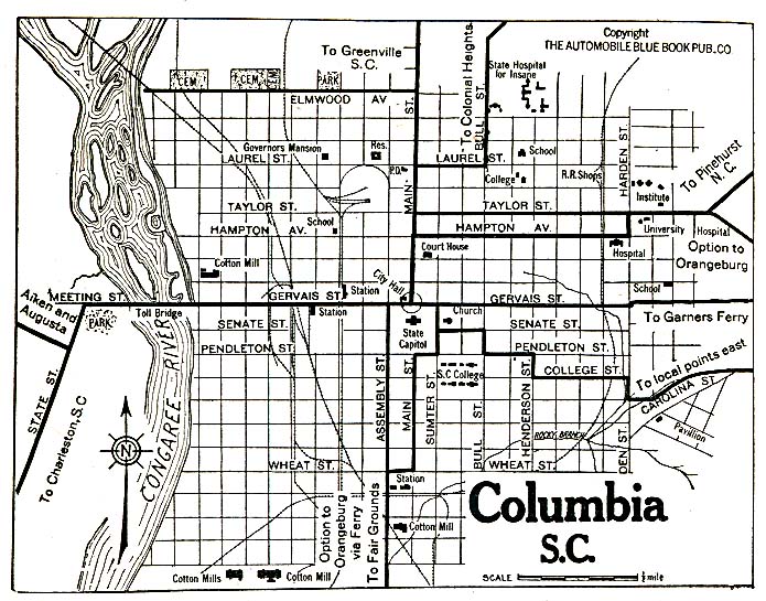
Columbia
- 1920
Search
All SC Categories
SC Bed & Breakfasts
SC Hotels
SC Businesses
SC Jobs
SC Churches
SC Maps
SC Cities
SC News
SC Colleges
SC Organizations
SC Elections
SC Photos
SC Entertainment
SC Real Estate
SC Events
SC Schools
SC Facts & Firsts
SC Taxes
SC Gifts
SC Vacations
SC Government
SC Webcams
SC History
SC Weddings
HOME
ABOUT
ADD INFO
ADVERTISE
CONTACT


